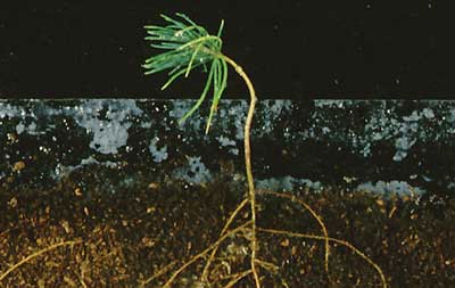
It takes 500 years to build up one inch of soil, according to the US Department of Agriculture. Yet we are losing this critical natural resource between 100 and 1000 times faster, through desertification, erosion, urban development and pollution. Understanding the weathering processes that both form and erode soil is a central focus for the WUN Critical Zone Observatories.
The Critical Zone
The Critical Zone is the thin outer layer of the Earth which sustains life, from the vegetation canopy to the soil and groundwater—or ‘tree top to bedrock’ as it is sometimes known. Soil is a key element of the critical zone, yet little is understood about how it forms.
The Critical Zone Observatories Consortium is a large collaborative project led by the University of Sheffield with scientists at the University of Leeds and University of Bristol. Through WUN, the experiment is able to move from the lab into the field, initially in the Critical Zone Observatory managed by Professor Brantley at Pennsylvania State University.
The observatory is one of six across the US, funded through the National Science Foundation, with plans underway for a further four in Europe.
Resources
Salts of the Earth (information sheet)
University leads the way in vital global soil research (press release)
SoilTrEc: Soil Transformations in European Catchments
Save Our Soils, Nature, 474, 151–152, (09 June 2011)
Watershed Re-analysis: Towards a Unified Framework for Model-Data Access, Analysis and Discovery Sub-project
To ensure a sustainable supply of clean water will require a new vision for the future role of models and supporting geospatial data in catchments. The lack of interoperability between water data, water models, and water simulations, and the lack of fast access between essential continental watershed data and computing resources, impedes efforts to solve such problems. Through this project, we are developing international collaborations that are defining the Essential Terrestrial Variables (ETV’s) and corresponding computational resources to support the development of multi-scale water models. The approach is based on extensions to existing frameworks and technologies and will efficiently support a federated, harmonized approach to data for modeling catchments at high resolution anywhere on the globe. A major outcome of this research is the prototype model-data infrastructure, which enables catchment-scale models anywhere in continental USA. We are working with WUN partners at international research observatories to implement the strategy at at sites in Europe (Wales, Switzerland, Crete, Czech Republic), where harmonized data and downscaled watershed re-analysis modeling products are resolving water and ecosystem services across multiple scales (100 to 104 km2) and multiple states (e.g. 30 year-hourly simulation of energy, snowmelt, soil moisture, groundwater, streamflow). The concept of interoperable geospatial data and models is becoming recognized as the major limitation and need for assessing and predicting the impact of change and change detection on future water supplies, water hazards, ecosystem services, water quality and health-related water issues.
The project involves collaborators from WUN members Bristol, Leeds and Sheffield, with WUN+ partners at Penn State University, the UK Centre for Ecology and Hydrology, the University of Reading, Technical University of Crete, and the University of Wisconsin.
Selected outcomes
- European Commission – Framework 7 Soil Transformations in European Catchments – €6,974,572.80
- European Commission 6th RTD Framework Global Change and Ecosystems (FP6). €649,980. 2007.
- Natural Environmental Research Council (NERC) Consortium Grant, Biologically-Mediated Weathering of Minerals, GBP£885,000, 2006.
- 78 academic publications.